The ‘LA fire is a tragedy’ thread
-
There is a lot of blame being tossed around, and I have to wonder how much of the criticism is valid. That said, I'll keep an open mind and wait for a "non-governement fuck-up" explanation for empty hyrants.
Arson? I saw a video done by someone stopped at a stoplight, and he caught someone setting a fire.
-
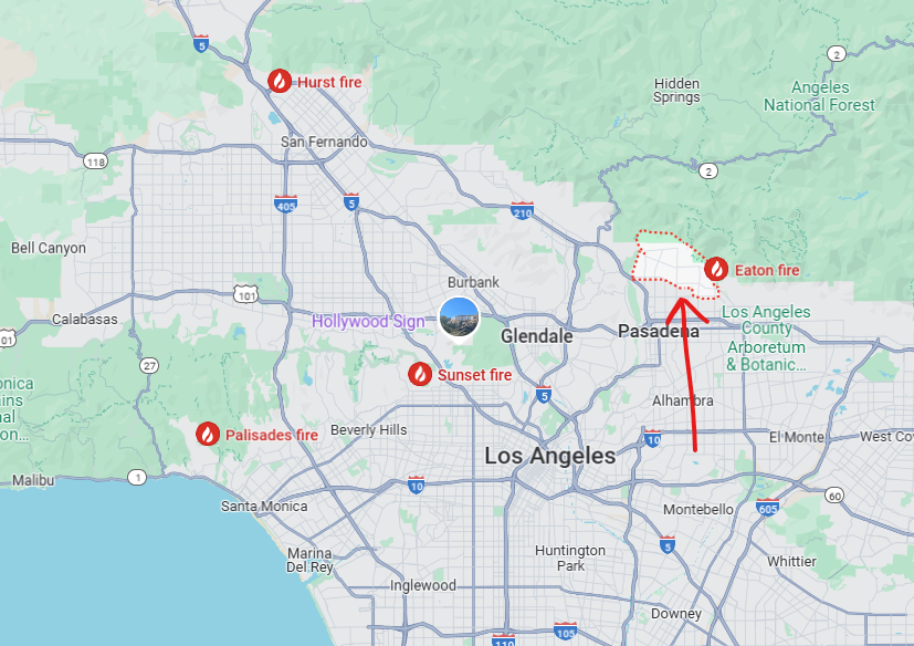
Can you zoom that out a bit so we can see where it is relative to the coastline? I assume it’s pacific pallasades.
@jon-nyc said in The ‘LA fire is a tragedy’ thread:
Can you zoom that out a bit so we can see where it is relative to the coastline? I assume it’s pacific pallasades.
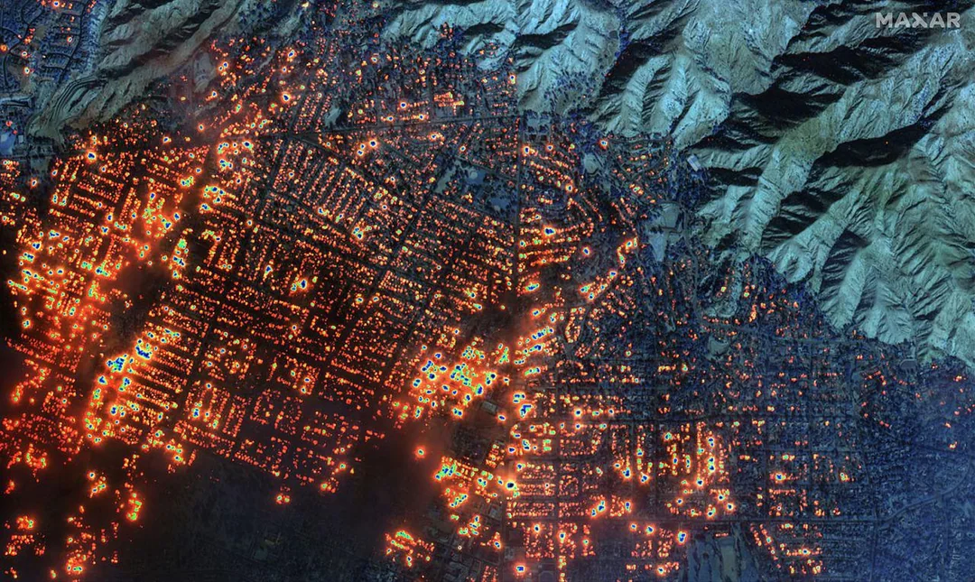
Western Altadena.
From reddit:
New satellite images from Maxar Technologies are giving the best view yet of just how many buildings are on fire in the Palisades and Eaton wildfires in Los Angeles.
The images were taken at 10:45 a.m. PT, during a time of significant cloud cover across the Los Angeles area.
Because of that, they are a mix of shortwave infrared and visible satellite images. Shortwave infrared sensors on Maxar’s satellites allow them to detect more things on the ground than are in the visible light spectrum – which is visible to the naked eye – such as heat signatures.
Everything illuminated in orange or white indicates locations where fire has been detected.
The imagery shows the Eaton wildfire has set nearly every building in western Altadena on fire. From the Altadena trailhead to the Mountain View Cemetery, the shortwave infrared sensor shows nearly every block is on fire. Those fires continue nearly all the way to Altadena’s east.
-
-
I've driven through those Hollywood Hills thinking, I know the views are terrific, but all those home are going to slide down into the canyons. I thought it would be floods or earthquake, not fire.
That is a huge amount of expensive real estate. I wonder if it will ever return to it's previous value.
-
I know 4 separate families whose homes have burned down. 3 in Pacific Palisades and 1 in Altadena. They are all desperately trying to find rentals, but not having any luck. I am about 35 miles south of Pacific Palisades, and even at that distance the fires seem huge.
-
Reports are the Kenneth fire was intentionally set. It’s a couple miles from my friends house in Westlake Village.
-
Hotel vouchers, FEMA trailers, churches, empty schools or other government buildings and long-term shelters. That's the short term.
Long term? For a lot of the average size homes, is there a "California-style" home that is a 3/2? Or a 2/2? A bungalow, perhaps? Optimize the plans for material use, where full sheets of plywood are used and none of the cutoffs are over six inches. Use fire resistant materials on the outside like Hardie Board or brick. Mandate metal roofs.
Offer six or seven plans like that for free, pre-approved by all zoning commissions and the state. And make those available in six weeks.
-
@George-K said in The ‘LA fire is a tragedy’ thread:
@Jolly said in The ‘LA fire is a tragedy’ thread:
make those available in six weeks.

I bet architects, developers and builders already know house plans that are much like that right now. Newsom could open up that competition in two weeks, with a 48 hour submission window. Have your approval commission already picked and lock the doors on them with a three day mandate for plan approval.
Winning plans would receive compensation and publicity for the submitters.
Hello! It looks like you're interested in this conversation, but you don't have an account yet.
Getting fed up of having to scroll through the same posts each visit? When you register for an account, you'll always come back to exactly where you were before, and choose to be notified of new replies (either via email, or push notification). You'll also be able to save bookmarks and upvote posts to show your appreciation to other community members.
With your input, this post could be even better 💗
Register Login